Basic Geography of Rajasthan
Introduction
- Rajasthan lies:
- With respect to India → North-Western
- With respect to World → North-Eastern
- The state’s total area is 10.43% (~10.41%) of India’s total area and India’s biggest state.
- Area-wise comparison of Rajasthan with other countries:
- Equal to Germany (3.57 Lakh sq. Km) & Japan (3.77 Lakh sq. Km)
- 5 times larger than Sri Lanka(0.65 lakh sq.Km)
- More than 17 times larger than Israel

Longitude and Latitude of Rajasthan

- Longitude:
- Longitude Extension: 69°30′ to 78°17′ East
- Longitudinal Difference: 8°47′
- Note:
- The local time difference between the east (Dholpur) to west (Jaisalmer) part of Rajasthan is about 35 minutes 08 second due to a longitudinal difference of 8°47′.
- Note:
- East point to West point of Rajasthan (Length) = 869 Km
- East point:
- Village – Jagmohan ka pura, Shilan ( Tehsil – Rajkhera, Dholpur)
- West point:
- Village – Katra ( Jaisalmer )
- East point:
- East point to West point of Rajasthan (Length) = 869 Km
- Latitude
- Latitude Extension: 23°03′ to 30°12′ North
- Latitude Difference: 7°09′
- Note:
- North point to South point of Rajasthan ( Broader ) = 826 Km
- North: Village – Kona ( Sri Ganganagar )
- South: Village – Borkund Chota ( Tehsil – Khushalgarh, Banaswara )
- Note:
- Difference between the longitudinal & Latitudinal length of Rajasthan is about 49 Km ( 869 – 826 Km )
- North point to South point of Rajasthan ( Broader ) = 826 Km
- Tropic of Cancer(23°30’ North latitude) passes through the southern district, namely Banswara, Dungarpur of Rajasthan.

Land Boundaries of Rajasthan
| Land Boundaries of Rajasthan ( Direction ) | |
| Direction | State(India)/Country |
| North | Punjab |
| North-East | Haryana & UP |
| East and South-East | MP |
| South and South-west | Gujarat |
| West | Pakistan |
- Total Land Boundary → 5,920 Km
- Interstate Land Boundary → 4,850 Km
- Note:
- Interstate consists: Punjab, Haryana, UP, MP and Gujarat
- Note:
- International Land Boundary(Rajasthan) → 1,070 Km
- Note:
- International line between India & Pakistan was established on 17 August 1947 by Sir Redcliffe, so the boundary line is known as the Redcliffe line.
- Total Length(India): 3,323 Km
- India’s 2 UT and 3 states attached with the Pakistan
- UTs → Ladhak(Capital Leh) and Jammu & Kashmir (Capital Srinagar)
- Punjab(-)
- Rajasthan(+)
- Gujarat
- 1070 Km = Hindumalkot ( Ganganagar ) to Shahgarh ( Barmer )
- Note:


| Rajasthan border districts with descending order | |
| Districts | Length (Km) |
| Jaisalmer | 464 |
| Barmer | 228 |
| Ganganagar | 210 |
| Bikaner | 168 |
Neighboring States
- Punjab — Rajasthan
| Punjab(2) | Rajasthan Districts(2) | Attachment length (Km) |
| Mukhtasar Fazilka | Hanumangarh(+) Ganganagar(-) | 89 |
- Haryana — Rajasthan
| Haryana(7) | Rajasthan Districts(7) | Attachment length (Km) |
| Hisar Sirsa Fatehabad Mahendragarh Bhiwani Rewari Mewat(Nuh) | Hanumangarh(+) Churu Jhunjhunu Sikar Jaipur(-) Alwar Bharatpur | 1262 |
- Uttar Pradesh — Rajasthan
| U.P(2) | Rajasthan Districts(2) | Attachment length (Km) |
| Mathura Agra | Bharatpur(+) Dholpur(-) | 877 |
- Madhya Pradesh — Rajasthan
| M.P(10) | Rajasthan Districts(10) | Attachment length (Km) |
| Jhabua Ratlam Mandsaur Sheopur Guna Shivpuri Murena Rajgarh Agar Malwa(Previous Shajhapur) Neemuch | Dholpur Karauli Sawai Madhopur Kota Baran Jhalawar (+) Chittorgarh Bhilwara (-) Pratapgarh Banswara | 1600 |
- Gujarat — Rajasthan
| Gujarat | Rajasthan Districts | Attachment length (Km) |
| Kutch Banas Kantha Sabarkantha Dahab Aravali Mahisagar | Banswara Dungarpur Udaipur(+) Sirohi Jalore Barmer(-) | 1022 |
Other Important
- Interstate boundary → 23 districts of Rajasthan
- 25 districts of Rajasthan → covers total boundary
- Intrastate boundary → 8 district
- Ajmer, Dausa, Tonk, Bundi, Rajasamand, Nagaur, Jodhpur & Pali
- Pali district is attached with maximum numbers of districts(8).
- Ajmer, Barmer, Udaipur, Nagaur, Jodhpur, Jalore, Sirohi, Rajsamand
- Nagaur & Jaipur attached with 7-7 districts


Origin & Evolution of Rajasthan
- Earth Formation
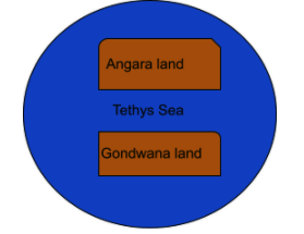
- Pangea(Continent part) consists 29% of the world
- Panthalassa(Oceanic part) consists 71% of the world

- Pangea divided into two part after millions of year
- Angara land
- Gondwanaland
- Rajasthan Formation
- Part of Tethys sea (New)
- The Desert and Eastern plain of Rajasthanis the Residue of Tethys sea.
- Salt lakes of the state like Sambhar, Deendwana, Pachpadra, Lunkaransar etc., are the remains of the Tethys sea.
- Part of Gondwanaland (oldest)
- Aravallis and the Deccan plateau(Hadoti) are part of Gondwanaland.
- Aravallis are one of the oldest mountains in the world.
- Aravallis acts as the major water-divide, making two divisions of the state.
- Physical features of any states represent the cumulative effect of:
- Endogenic movements
- Geological structure
- Denudation
- Drainage pattern
- State’s relief comprises
- Mountains
- Plains
- Plateaus
- Deserts
- Part of Tethys sea (New)