Climate
- Climate is an important geographical factor that influences the natural elements and affects the economic and demographic aspects.
- The average weather conditions of a large area taken for a long period (for more than thirty years) is known as the climate of that region, whereas the sum of atmospheric conditions of a place at a particular time is called the weather of that place.
- Temperature, atmospheric pressure, winds, rainfall, duration of the day etc., are the climate elements.
- Temperature is the primary climate component because other climate elements are directly or indirectly associated with temperature.
- The world has been divided into torrid, temperate and frigid zones based on temperature.
- Similarly, rainfall patterns are the fundamental element in the determination of climatic regions. The humid, sub-humid and dry climatic categories are based on it.
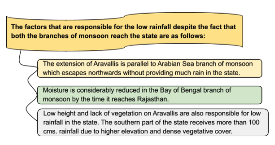
- The climate of Rajasthan varies from dry to sub-humid monsoon type.
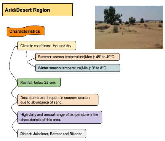
- The dry climate full of high daily and annual range of temperature, low rainfall, hot scorching Loo and sand storms is the climatic characteristics of western Rajasthan.
- In contrast, comparatively low temperatures, a low range of temperature, and slightly higher rainfall are the characteristics of sub-humid climate to the east of the Aravallis.
- Major factors that affect Rajasthan climate are:
- Latitudinal location
- Distance from the sea
- Altitude above sea level
- Location and direction of Aravallis
- Soil structure and vegetative cover
Climatic Characteristics of Rajasthan
- Rajasthan enjoys a dry and sub-humid monsoon type of climate.
- The distribution of rainfall is highly unequal.
- The daily and annual range of temperature remains high due to the abundance of sand.
- The maximum daily temperature touches the mark of 49°C in the summer season.
- The hot, dry, and stormy Loo blows in summer.
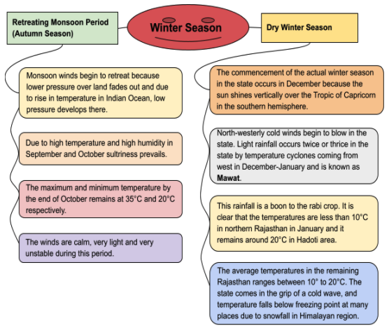
- At some places, the temperature falls to freezing point in the winter season.
- Maximum rainfall occurs in the rainy season. The quantity of rain decreases from east to west and south to north.
- Droughts and famines are frequent here. It is a proverbial saying about the famine’s extension that the famine legs spread up to Pongal (a place of Bikaner).
- The main body spreads Kotre (Marwar), stomach at Bikaner, a strayed occurrence at Jodhpur and permanent in Jaisalmer.

Seasons of Rajasthan


Climatic Region
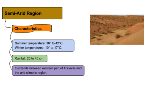
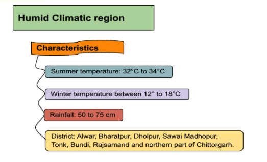
- Based on temperature and rainfall, Rajasthan can be divided into 4 major climatic regions.

Koppen Classification
- Koppen’s climate classification is based on vegetation, taking into account the importance of temperature and rainfall.
- Koppen’s formulas are in some way fine for the lower regions but prove unusable for higher regions.
- According to Koppen classification, we can divide the climatic region of Rajasthan into 4 regions, namely:
- Aw
- Bshw
- BWhw
- Cwg
- Aw (Tropical wet and dry climate, also known as the savanna climate)
- District: Southern part of Dungarpur, Banswara, Jhalawar and Baran
- Vegetation: Savanna Grass, Deciduous trees of Monson type.
- Average Rainfall: 80-90 cm
- Summer temp: 30 to 34°C; and Winter: 12 to 15°C
- BShw(Semi-arid Steppe type)
- District: Barmer, Nagaur, Jalore, Jodhpur, Pali, Churu, Sikar, Jhunjhunu, south-east Hanumangarh
- Vegetation: Steppy Grass
- Average Rainfall: 20 – 40cm
- Summer temp: 32 to 35°C; Winter temp: 15 to 20°C
- BWhw(Hot desert type)
- District: North-western Jodhpur, Jaisalmer, Bikaner and Shri Ganganagar.
- Average Rainfall: 10-20cm
- Summer temp: average 35°C; Winter temp: 12 to 18°C
- Cwg(Monsoon type with dry winters)
- Region: South-eastern and East of Aravalli range(Udaipur, Dungarpur, Pratapgarh, Bhilwara, Rajsamanad, Chittorgarh, Bundi, Kota, Baran, Tonk, Ajmer, Sawai Madhopur, Karoli, Jaipur, Dausa, Alwar, Bharatpur, Dholpur)
- Average Rainfall: 60 – 80 cm
Agro-Climatic Zone(Rajasthan)
| Area/Zone | Total Area(million ha) | District Covered |
| Hyper arid partial irrigated Zone(IC) | 7.70 | BikanerJaisalmerChuru |
| Arid western plain(IA) | 4.74 | Barmer Part of Jodhpur |
| Internal drainage dry zone(IIA) | 3.69 | NagaurSikarJhunjhunuPart of Churu |
| Sub-humid southern plains(IVA) | 3.36 | BhilwaraSirohiUdaipurChittorgarh |
| Transitional plain of Luni basin(IIB) | 3.00 | JalorePaliJodhpurPart of Sirohi |
| Semi-arid eastern plains(IIIA) | 2.96 | JaipurAjmerDausaTonk |
| Flood prone eastern plain(IIIB) | 2.77 | AlwarDholpurBharatpurKaroliSawai Madhopur |
| Humid south-eastern plain(IVB) | 2.70 | KotaJhalawarBundiBaran |
| Irrigated north-western plain(IB) | 2.10 | Sri GanganagarHanumangarh |
| Humid southern plains(IVB) | 1.72 | DungarpurUdaipurBanswaraChittorgarh |
